
Page 136 - Greystones Archaeological Historical Society
P. 136
CÚL OF THE ROCK
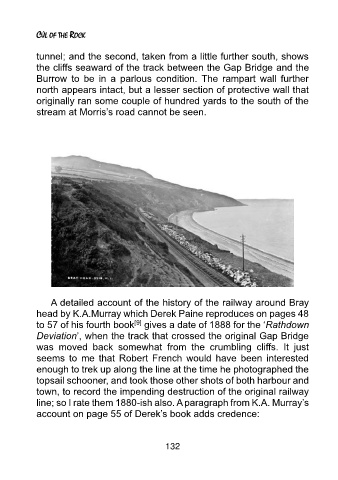
tunnel; and the second, taken from a little further south, shows
the cliffs seaward of the track between the Gap Bridge and the
Burrow to be in a parlous condition. The rampart wall further
north appears intact, but a lesser section of protective wall that
originally ran some couple of hundred yards to the south of the
stream at Morris’s road cannot be seen.
A detailed account of the history of the railway around Bray
head by K.A.Murray which Derek Paine reproduces on pages 48
[9]
to 57 of his fourth book gives a date of 1888 for the ‘Rathdown
Deviation’, when the track that crossed the original Gap Bridge
was moved back somewhat from the crumbling cliffs. It just
seems to me that Robert French would have been interested
enough to trek up along the line at the time he photographed the
topsail schooner, and took those other shots of both harbour and
town, to record the impending destruction of the original railway
line; so I rate them 1880-ish also. A paragraph from K.A. Murray’s
account on page 55 of Derek’s book adds credence:
132