
Page 141 - Greystones Archaeological Historical Society
P. 141
GREYSTONES ARCHAEOLOGICAL & HISTORICAL SOCIETY JOURNAL VOLUME 8
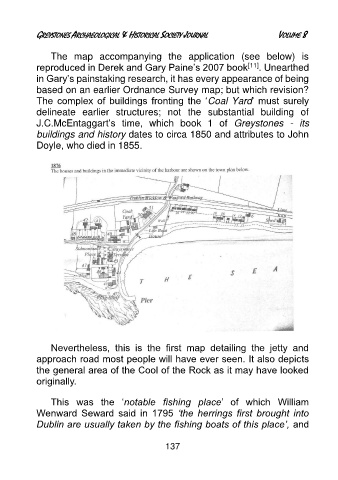
The map accompanying the application (see below) is
reproduced in Derek and Gary Paine’s 2007 book [11] . Unearthed
in Gary’s painstaking research, it has every appearance of being
based on an earlier Ordnance Survey map; but which revision?
The complex of buildings fronting the ‘Coal Yard’ must surely
delineate earlier structures; not the substantial building of
J.C.McEntaggart’s time, which book 1 of Greystones - its
buildings and history dates to circa 1850 and attributes to John
Doyle, who died in 1855.
Nevertheless, this is the first map detailing the jetty and
approach road most people will have ever seen. It also depicts
the general area of the Cool of the Rock as it may have looked
originally.
This was the ‘notable fishing place’ of which William
Wenward Seward said in 1795 ‘the herrings first brought into
Dublin are usually taken by the fishing boats of this place’, and
137